3D Scanning a Monument with SLAM LiDAR: Capturing the Lac Bird Symbol at Lang Cha Ca Roundabout in One Day
3DSCAN captured the as-built geometry of the Lac Bird (Chim Lạc) symbol at Lang Cha Ca roundabout, Ho Chi Minh City, using a ComNav LS600 SLAM LiDAR scanner combined with site photography – one day in the field, data delivered on day two. The data allowed GENERAL E&C, the main contractor responsible for the artistic lighting design, to position luminaires on the sculpture's actual built form instead of hand-measuring each detail and modelling it manually. The project is an application of our as-built architectural laser scanning service for free-form public structures.
Plan a 3D scan around your project schedule
How SLAM works: the engineer walks around the plinth while the scanner records the form as a 3D point cloud on the move.
Lighting design needs the real form, not just overall dimensions
Lang Cha Ca roundabout is a gateway junction in north-western Ho Chi Minh City, on the main route to Tan Son Nhat International Airport. Tuoi Tre newspaper reported on 4 July 2026 that the new Lac Bird symbol was completed here to mark the 50th anniversary of Saigon – Gia Dinh being renamed after President Ho Chi Minh (Tuoi Tre article on the new Lac Bird symbol at Lang Cha Ca).
On a sculptural work, uplighting only succeeds when the light follows the curve of each wing. The designer needs a 3D geometric replica of the symbol as built to work out fixture positions, aiming angles and shadowed areas. GENERAL E&C's requirement was explicit: survey on day one, receive the data on day two.
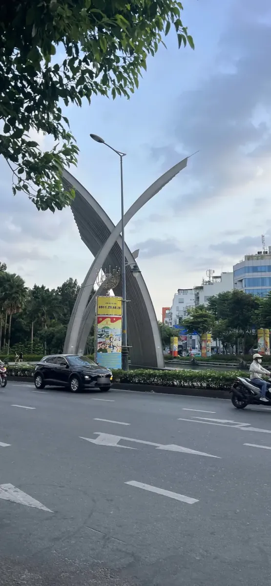
The Lac Bird symbol: tall, curved metal wings crossing each other.
One day on site made SLAM the choice over hand measurement or static scanning
SLAM LiDAR met three constraints at once: a short time on site, free-form curved surfaces and continuous traffic around the junction. The table below summarises how 3DSCAN weighed the options.
Choosing a survey method for a monument in a busy junction
| Method | Time on site | Free-form surfaces | Best suited when |
|---|---|---|---|
| Hand measurement + total station | Long; grows with the number of points | Discrete points only; curves must be inferred | Simple forms needing a few key dimensions |
| Static laser scanning (Leica RTC360) | Medium: multiple setups around the sculpture | Complete, high density, up to 2,000,000 points per second | Highest accuracy required: heritage records, Scan to BIM |
| UAV photogrammetry (DJI Mavic 3E) | Short, if flight is permitted | Good on outer faces, limited on inner wing faces | Airspace is permitted; next to an airport, approvals rarely fit a one-day schedule |
| SLAM LiDAR (ComNav LS600) – chosen for the Lac Bird | Short: walk around the sculpture | Continuous, including inner wing faces and the crossing zone | Speed matters, heavy traffic, data for design use |
The ComNav LS600 is a handheld SLAM LiDAR scanner with integrated RTK, capturing up to 640,000 points per second according to 3DSCAN's equipment profile. The engineer scans while walking; the SLAM algorithm computes the trajectory and merges everything into one continuous point cloud, with no need to set up at each station as in static LiDAR scanning of buildings. The trade-off is lower accuracy than static scanning – acceptable for lighting design.
Walking around the symbol: laser for geometry, photos for surfaces
On site, the 3DSCAN engineer carried the LS600 along closed loops around the plinth, aiming at hard-to-see faces such as the inner wing surfaces and the zone where the two wings cross. Closing the loop lets the SLAM algorithm correct accumulated drift when the scanner returns to its starting point.
Site photos record materials and joints for cross-checking during point cloud cleaning.
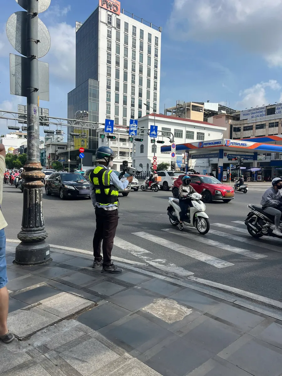
A 3DSCAN engineer with the ComNav LS600 at the Lang Cha Ca junction.
31-second video: continuous SLAM scanning across the pedestrian crossing, timed with the traffic lights.
The video and photos show the real site conditions: wearing a high-visibility vest, the engineer waits for the signal, then crosses the road while the scanner keeps recording as motorbikes and cars move around the junction. Traffic could not be stopped, so a handheld scanner that captures on the move was the only workable option.
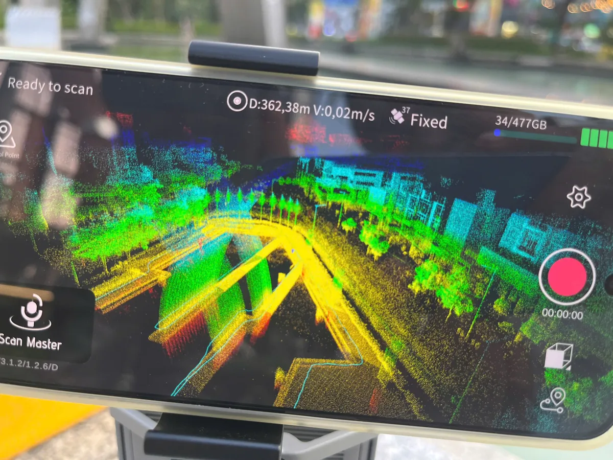
LS600 controller on site: the point cloud appears as you scan, RTK Fixed with 37 satellites.
The controller displays the point cloud live, together with the walking trajectory and a positioning status of RTK Fixed with 37 satellites. The engineer sees any gaps immediately and fills them on the spot, avoiding a return visit.
Two days, six steps: from point cloud to design-ready data
Schedule: fieldwork on day 1, data processing, delivery on day 2.
The workflow has six steps: (1) SLAM scanning around the symbol; (2) site photography; (3) trajectory computation and point cloud merging; (4) cleaning – removing vehicles, people and vegetation, and cross-checking against photos; (5) checking and exporting in the agreed formats; (6) delivery to GENERAL E&C on day two.
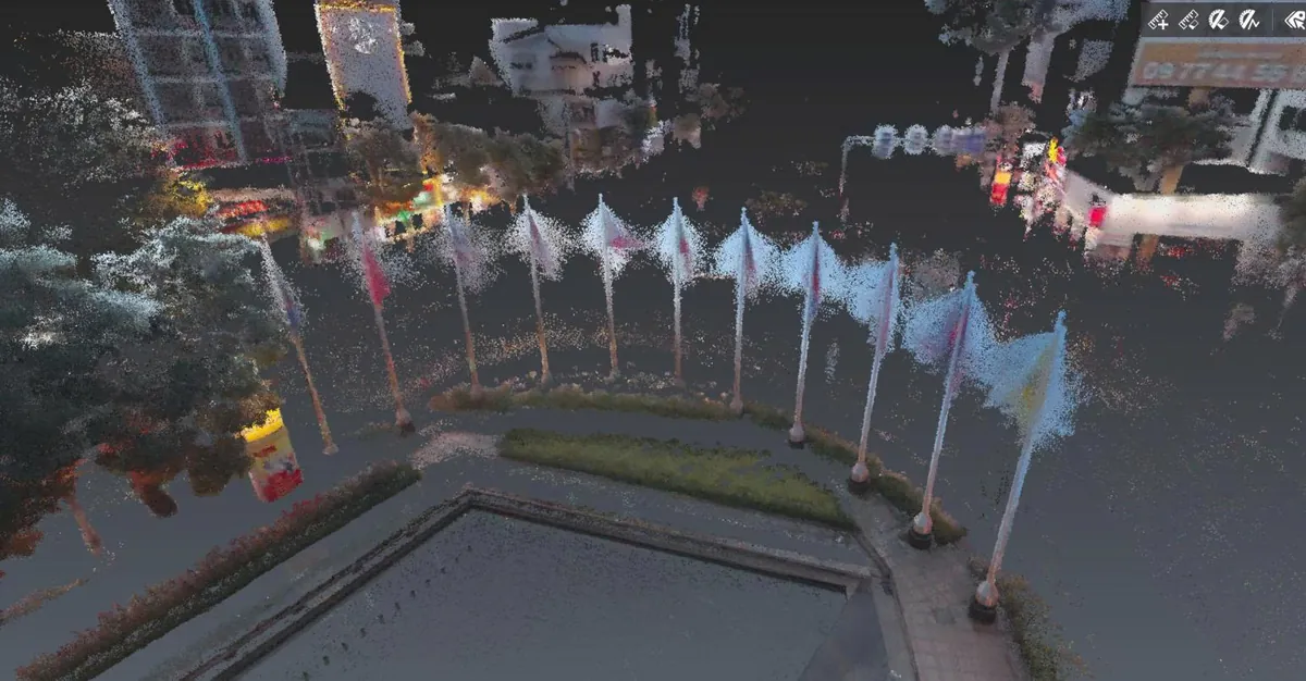
Processed colourised point cloud: flagpoles, water feature, lawn and shophouse facades around the roundabout.
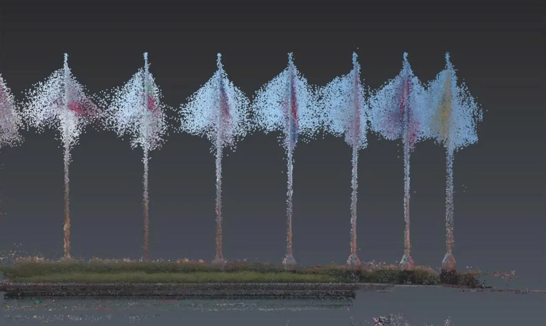
Elevation extracted from the point cloud: flagpole heights, kerb and spacing between elements can be measured directly.
The deliverable is an as-built geometric base and is not the same as a BIM model or a finished surface model. When needed, the same point cloud serves as the basis for 3D modelling from scan data or for a Scan to BIM workflow.
Quality checks and deliverables
Before export, the data is checked for continuity between scan passes and its shape is compared against the site photos.
- Colourised 3D point cloud of the symbol and the roundabout space
- Site photo set for cross-checking materials and sculptural details
What 3D data lets a lighting designer work out
Three lighting design decisions based directly on the scanned form.
With the real form in hand, GENERAL E&C moved trial and error from the junction to the computer:
- Aiming angles: knowing which way each curved face points, so light grazes along the wings instead of flattening them.
- Shadowed areas: inner wing faces and the crossing zone, shaded by the sculpture itself, are identified before any fixture is installed.
- Fixture positions: placed on the plinth and roundabout floor based on true distances to each face of the sculpture.
Lesson learned: speed comes from agreeing deliverables before going on site
A “scan on day one, deliver on day two” schedule works when the intended use of the data is agreed with the designer from the start: what the data is for, which formats, and how much density is enough. A fast scanner only shortens data capture; the rest is process.
The same approach applies to monuments, landscape features and art architecture – as in our 3D model of Tan Hue Vien tourist area.
Conclusion
The Lac Bird symbol project at Lang Cha Ca roundabout shows that SLAM LiDAR scanning can meet urgent survey assignments in the middle of a busy city. From our head office in Ho Chi Minh City, 3DSCAN is ready to work with design firms to bring real structures into the digital environment on schedule.
Related projects by 3DSCAN
- 3D model of Tan Hue Vien tourist area — as-built data supporting the design of artistic architecture.
- 3D laser scanning of Xa Loi Pagoda — recording the geometry of a religious landmark in Ho Chi Minh City.
- 3D scanning of St. Joseph's Cathedral, Hanoi — digitising a building with complex detailing.
- Heritage conservation survey services — workflow, deliverables and project scope.
Need a monument, landmark or art installation 3D scanned on a tight schedule? Send 3DSCAN the scope, intended use of the data and your deadline – our engineers will propose a suitable method and survey schedule.
Contact 3DSCAN Hotline: 0938 309 808 · Email: lienhe@3dscan.vn

Frequently asked questions (FAQ)
How long does it take to 3D scan an outdoor sculpture?
Is a SLAM scanner as accurate as a static laser scanner?
Why not use a drone to capture the sculpture at Lang Cha Ca roundabout?
Does 3DSCAN scan monuments and public structures in Ho Chi Minh City and Hanoi?
Sources: Tuoi Tre newspaper (4 July 2026); 3DSCAN equipment profile. Project scope, partner and schedule provided by 3DSCAN.